OUR SERVICES
OUR SERVICES
In a world driven by precision, efficiency, and actionable insights, our geospatial drone services are revolutionizing how industries visualize, analyze, and interact with the Earth’s surface. By combining cutting-edge drone technology with advanced mapping and data analytics, we deliver unparalleled accuracy, speed, and detail—empowering businesses, governments, and organizations to make smarter decisions, faster.
Why Choose Our Geospatial Drone Services?
Unmatched Precision
Capture centimeter-level accuracy with LiDAR, photogrammetry, and multispectral sensors for hyper-detailed terrain modeling and 3D mapping.
Rapid Data Acquisition
Survey vast areas in hours—not weeks—reducing project timelines and enabling real-time decision-making.
Cost Efficiency
Slash expenses tied to traditional surveying, manual labor, or satellite imagery while maintaining superior data quality.
Actionable Insights
Transform raw geospatial data into strategic intelligence with AI-powered analytics for risk assessment, resource optimization, and trend forecasting.
Scalability
Adapt seamlessly to projects of any size, from urban planning and agriculture to disaster response and environmental conservation.
Unmatched Precision
Capture centimeter-level accuracy with LiDAR, photogrammetry, and multispectral sensors for hyper-detailed terrain modeling and 3D mapping.
Rapid Data Acquisition
Cost Efficiency
Actionable Insights
Scalability
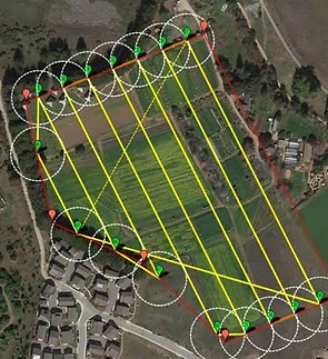
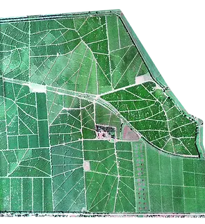
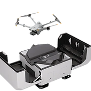
Land Survey
Capture precision-crafted 2D/3D models faster—survey larger areas, enhance survey safety, and slash operational costs with drone-powered efficiency. Visualize results with accurate, high-resolution maps, Point Clouds, and 3D models.
Mining Survey
Cadastral Survey
Construction Monitoring
Welcome to the future of geophysical exploration—where cutting-edge technology meets the Earth’s hidden secrets. At Skyway UAS, we revolutionize how industries uncover critical insights about the subsurface world with our advanced drone geophysical services.
Gone are the days of slow, costly, and labor-intensive traditional survey methods. By harnessing the power of unmanned aerial systems equipped with state-of-the-art sensors, we deliver faster, safer, and more precise geophysical data—whether you’re mapping mineral deposits, assessing groundwater resources, analyzing terrain stability, or planning infrastructure projects.
Our drones soar above rugged landscapes, environmentally sensitive zones, and hard-to-reach areas, capturing high-resolution magnetic, electromagnetic, radiometric, or LiDAR data without disturbing the ground. The result? Unmatched accuracy, reduced risks, and actionable insights—all while slashing project timelines and costs.
Why Choose Our Geophysical Drone Services?
Cutting-Edge Technology
Equipped with advanced magnetic, electromagnetic, radiometric, and LiDAR sensors, our drones deliver unparalleled data quality. Proprietary processing algorithms transform raw data into actionable insights with pinpoint accuracy.
Rapid Deployment & Efficiency
Conduct surveys in days, not weeks. Our drones cover vast or rugged terrain swiftly, accelerating project timelines and enabling faster decision-making—without compromising detail.
Safety First
Eliminate risks to personnel in hazardous or inaccessible environments. Our drones operate in challenging zones—steep slopes, unstable terrain, or ecologically sensitive areas—keeping your team safe.
Cost-Effective Solutions
Slash costs by up to 60% compared to traditional methods. Reduce labor, equipment, and ground disturbance expenses while maintaining high-resolution data integrity.
Cutting-Edge Technology
Equipped with advanced magnetic, electromagnetic, radiometric, and LiDAR sensors, our drones deliver unparalleled data quality. Proprietary processing algorithms transform raw data into actionable insights with pinpoint accuracy.
Rapid Deployment & Efficiency
Safety First
Cost-Effective Solutions
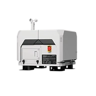
Radiometric Survey
Magnetic Survey
LiDAR Survey
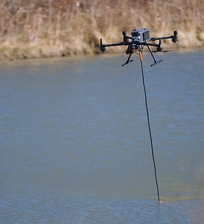
Bathymetry Suvey
Why Choose Our Drone Asset Inspections?
Enhanced Safety
Eliminate the need for manual inspections in hazardous or elevated environments.
Efficiency & Accuracy
Rapid data collection and real-time insights reduce downtime and enable predictive maintenance.
Cost Efficiency
Slash expenses tied to traditional surveying, manual labor, or satellite imagery while maintaining superior data quality.
Cost Savings
Minimize labor, equipment, and operational costs compared to traditional methods.
Comprehensive Reporting
Detailed analytics.
Enhanced Safety
Eliminate the need for manual inspections in hazardous or elevated environments.
Efficiency & Accuracy
Cost Efficiency
Cost Savings
Comprehensive Reporting
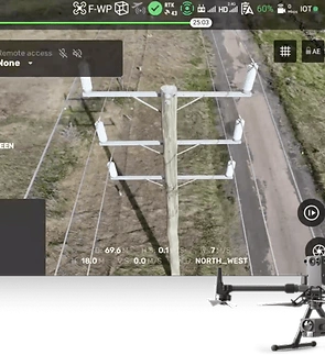
Powerline Monitoring
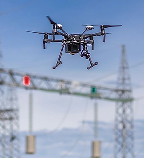
Substation Inspection
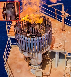
Industrial Inspection
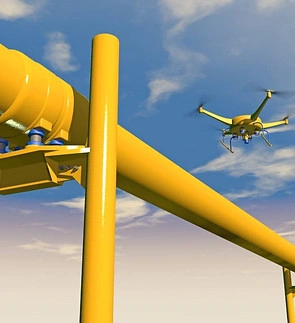
Pipeline Inspection
Modernize pipeline integrity management with drone-driven inspections designed to ensure safety, compliance, and operational efficiency. Equipped with high-resolution cameras, thermal sensors, gas detectors, and LiDAR, our UAVs swiftly survey vast pipeline networks—including remote or inaccessible areas—to identify risks such as corrosion, leaks, encroachments, ground subsidence, or coating damage.
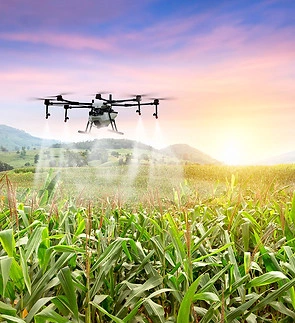
Our drones are transforming agriculture by offering precision, data-driven solutions to optimize crop management and boost productivity. Key services include.
Why Choose Our Agricultural Drone Services?
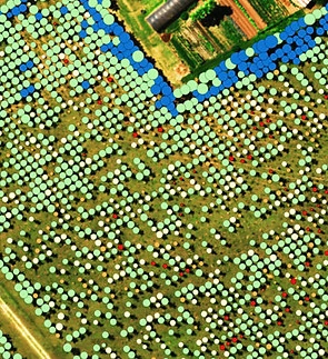
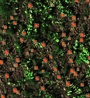
Crop Monitoring & Analysis
High-resolution aerial imagery and multispectral sensors track plant health, detect pests/diseases, and monitor growth stages in real time.
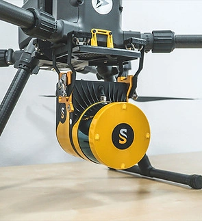
Precision Spraying
Drones apply fertilizers, pesticides, and herbicides with pinpoint accuracy, reducing chemical use and costs while minimizing environmental impact.
Cost Efficiency
Slash expenses tied to traditional surveying, manual labor, or satellite imagery while maintaining superior data quality.
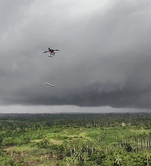
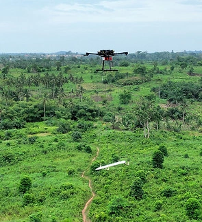
Planting & Seeding
Automated drone systems disperse seeds or seedlings in hard-to-reach areas, improving reforestation and crop uniformity.
Irrigation Management
Thermal cameras identify dry zones, enabling targeted water use and efficient irrigation planning.
Crop Monitoring & Analysis
High-resolution aerial imagery and multispectral sensors track plant health, detect pests/diseases, and monitor growth stages in real time.
Precision Spraying
Cost Efficiency
Planting & Seeding
Irrigation Management
Crop Monitoring
Crop Spraying
Irrigation Management
Farm Mapping
Drone Implementation Strategy
Companies that have no idea where to begin with in their drone programs can rely on our methodology to facilitate easy RPAS evaluation, RPAS manual review and RPAS training.
Drone Hardware Evaluation

RPAS Operating Certificate Support
Global Drone Partners
At the heart of our mission to harness drone technology on the continent lies our unparalleled network of global drone partners. Spanning continents and uniting the brightest minds in hardware and software these collaborations empower us to deliver transformative solutions tailored to the unique challenges of data acquisition using drones.
Our partners are more than industry leaders—they are visionaries redefining technology with drones. Together, we integrate advanced UAV systems, AI-driven analytics, and localized wisdom to create a wider use of drones in Africa.